Atmospheric Observation by Aircraft -CONTRAIL project-
Overview
The JAL Group began the atmospheric observation in 1993, and launched the CONTRAIL* Project in 2005, in order to expand the scope of observation. The CONTRAIL project is a continuous global-scale observation of greenhouse gases by regular passenger flights, consisting of five organizations (National Institute for Environmental Studies, Japan Meteorological Agency, JAMCO Corporation, JAL Foundation, and Japan Airlines). The government and companies worked together to continue the project, and observations are now being conducted on the Boeing 777 aircraft.
* Comprehensive Observation Network for Trace gases by Airliner
Target
The objective of this project is to clarify the mechanisms of the global carbon cycle using commercial aircraft to monitor greenhouse gases over a wide area and observe any changes.
History of the project
Commencement of the project
For two years from 1984, we collaborated with Tohoku University to observe the concentration of carbon dioxide in the upper atmosphere between Narita-Sydney and between Narita-Anchorage using air sampling by manual pumps. This was the world's first attempt to observe the atmosphere by latitude on a regular international passenger flight.
Extensive and highly-frequent observation with installation of on-board equipment
Air sampling had been conducted manually in the beginning. However, with the installation of a CO2 concentration measuring device on a Boeing 747-400 (retired aircraft), a more frequent observation of CO2 concentrations over a wider area became possible.
Measuring equipments
Three types of instruments are in operation for this observation: Automatic air Sampling Equipment (ASE), Continuous CO2 Measuring Equipment (CME), and Manual air Sampling Equipment (MSE), all of which were developed and manufactured for this purpose. The first two of these instruments were developed in cooperation between Tohoku University and the Japan Aerospace Exploration Agency (JAXA) in addition to the five organizations mentioned before.
In order to install these devices, the aircraft must undergo special airframe modifications and airworthiness testing for the modifications, and be approved by the Federal Aviation Administration (FAA) and the Civil Aviation Bureau of the Ministry of Land, Infrastructure, Transport and Tourism.
Findings from the observation
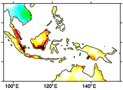
Large-scale CO2 emissions from tropical regions due to forest fires
In 2015, a drought caused by a very strong El Niño condition led to large-scale peat and forest fires in island regions of Southeast Asia, and CO2 emissions from it were observed through high-precision on-site observations by CONTRAIL and cargo ships. By analyzing these observations using an atmospheric simulation model, CO2 emissions from large-scale fires in the Southeast Asian island region during September-October 2015 were estimated to be 273 Tg (carbon equivalent), equivalent to the annual emission from the whole country of Japan. This is the first estimation of CO2 emissions from a large-scale fire in 2015 that uses high-precision in-situ observation data. The amount of CO2 emissions from peat and forest fires in the area is extremely large, and the continuous monitoring by observation is important for the future.
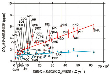
CO2 emissions from urban areas
By analyzing the CO2 concentration observation data acquired by the CONTRAIL project over a 10-year period from 2005 to 2016, characteristics of CO2 concentration variations directly above 34 cities around the world were clarified. Comparing the upwind and downwind sides of each city, a significant increase in CO2 concentration was observed downwind of the city, indicating the influence of CO2 emissions in the urban area. Therefore, it became clear that there is a correlation between the influence of CO2 emissions from the city and the fluctuation range of CO2 concentrations. The larger the CO2 emissions, the larger the fluctuation range. It is expected that this observation data will be utilized to monitor CO2 emissions in urban areas and around the world in the future, thus contributing to improving the accuracy of greenhouse gas inventories.
This research and development was supported by the Ministry of the Environment Global Environment Conservation Examination and Research Fund (Task of MOE and MLIT: Env. 1652).
Partnership
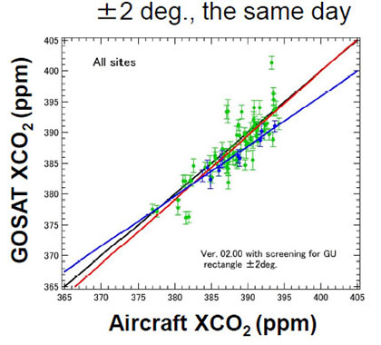
Cooperation with the "GOSAT" (Greenhouse gases Observing Satellite)
Observation data obtained by JAL aircraft participating in the CONTRAIL project are also used for the verification of greenhouse gas observations by "GOSAT" and "GOSAT-2". In the verification, 72% of the aircraft observation data used were CONTRAIL data.
Awards
Words from experts
MACHIDA Toshinobu, Head of Office for Atmospheric and Oceanic Monitoring, Center for Global Environmental Research, Earth System Division, National Institute of Environmental Studies
This is the first project in the world to measure and accumulate the concentration of greenhouse gases on a global scale at at frequent intervals, and the observation data is attracting attention as valuable data for researchers around the world who are investigating global warming and its mechanisms.
Continuous measurement by CME, which began in 2005, has four revolutionary advantages. Firstly, "daily measurement" is possible, which means that data can be obtained frequently. Secondly, it is possible to measure CO2 concentrations in various parts of the world. Thirdly, it is possible to measure the vertical distribution of CO2 from the ground surface to the sky at different heights. Finally, it is possible to obtain spatially detailed distributions. The third, "vertical distribution," is particularly important as the data can be used as an indicator of the amount of CO2 released (or absorbed) by the land surface as the sum of land plants, oceans, and human activities, and it is also an extremely useful information for verifying vertical transport, which is the most uncertain aspect of atmospheric flow. These vertical distribution data are still only available in limited locations around the world. CONTRAIL is a groundbreaking project that will make it possible to obtain this information frequently and regularly.
CONTRAIL data are widely distributed to researchers in Japan and overseas for use in studies of the global carbon cycle and atmospheric transport, as well as for validation of satellite observations. In 2018, CME data was released to the public with a globally common identification number called DOI (Digital Object Identifier). The assignment of DOIs will make it extremely easy to use data in accordance with the rules, and is expected to further expand the use of CONTRAIL data. In 2019, a portion of the ASE data has been released with a DOI, and in 2021, the "latest data" including data less than one year old after observation were released. The results of research using CONTRAIL data have been published in 65 peer-reviewed international journals.